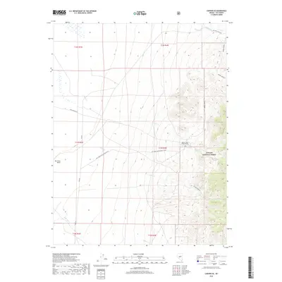
2018 Map of Carvers SE
USGS Topo · Published 2018About this map
Toiyabe National Forest dominates the eastern high ground of this landscape, where the terrain rises sharply from the valley floor. Numerous drainages such as Barker Cr, Willow Cr, and Anderson Cr flow westward from the mountains, carving deep canyons into the slopes. The transition from the alluvial fans to the forested uplands is marked by a network of specialized access routes, including Berg Fenceline Rd and Natl Forest Develop Road 158 Rd. Central to the ranching and aviation history of this specific Nye County pocket is the Barker Creek Ranch Airstrip, situated where the creek emerges from the canyon mouth. The map provides a detailed view of the infrastructure supporting this high-desert environment, from the Moore's Ranch Rd to the various unnamed tracks that navigate the foothills.
Find a feature on this map
21 named features on this map. Tap any name to fly to it.
Don’t see what you’re looking for? This feature index may not catch every label — zoom into the map to look around manually.
Map Details
Editions of this 2018 Carvers SE Map
This is the sole edition of this map. No revisions or reprints were ever made.
Other maps of this area

1907 · Tonopah
USGS Topo · 1:250,000

1908 · Tonopah
USGS Topo · 1:250,000

1956 · Tonopah
USGS Topo · 1:250,000

1959 · Tonopah
USGS Topo · 1:250,000

1962 · Tonopah
USGS Topo · 1:250,000

1971 · Carvers NW
USGS Topo · 1:24,000

1971 · Carvers
USGS Topo · 1:24,000
1971 · Jet Spring
USGS Topo · 1:24,000

1971 · Pablo Canyon Ranch
USGS Topo · 1:24,000
1971 · Carvers NE
USGS Topo · 1:24,000