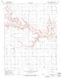
1968 Map of Carwood Cemetery
USGS Topo · Published 1993About this map
Ladder Creek carves a significant drainage through the High Plains of Wichita County, defining the central landscape of this 1968 survey. The creek's winding path creates a stark contrast to the surrounding plateau, where small community anchors like Parks Ch and the Carwood Cem provided social and spiritual focal points for the rural population. These landmarks, along with a Gravel Pit and scattered wells, illustrate a local economy tied to the land and its resources. The northern extent of Leoti reaches into the southern portion of the quadrangle, showing the relationship between the township and the open range of Beaver terrain. This document preserves the mid-century layout of section lines and fence lines that continue to structure the agricultural life of western Kansas.
Find a feature on this map
9 named features on this map. Tap any name to fly to it.
Don’t see what you’re looking for? This feature index may not catch every label — zoom into the map to look around manually.
Map Details
Editions of this 1968 Carwood Cemetery Map
2 editions found
Other maps of this area

1955 · Scott City
USGS Topo · 1:250,000

1958 · Scott City
USGS Topo · 1:250,000

1968 · Russell Springs 3 SW
USGS Topo · 1:24,000

1968 · Russell Springs 3 NW
USGS Topo · 1:24,000

1968 · Russell Springs 3 SE
USGS Topo · 1:24,000

1968 · Sharon Springs 4 NE
USGS Topo · 1:24,000

1968 · Russell Springs 3 NE
USGS Topo · 1:24,000

1970 · Sharon Springs 4 SE
USGS Topo · 1:24,000

1970 · Selkirk
USGS Topo · 1:24,000

1970 · Leoti
USGS Topo · 1:24,000