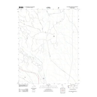
2012 Map of Casa Diablo Mountain
USGS Topo · Published 2012About this map
Casa Diablo Mountain dominates the high desert landscape of Mono County in this early 21st-century survey. The terrain is defined by a network of seasonal water sources and historical transit routes, including the Old Sherwin Grade and the Lower Rock Creek Rd which wind through the foothills near Sherwin Hill. The presence of Mesa Camp and the Casa Diablo Mine Rd suggests a legacy of seasonal habitation and resource extraction. The Owens River and Lower Rock Cr provide critical drainage through the arid flats, while engineering features like Tunnel Number Two indicate the management of water or transportation through the mountain passes. Modern US Forest Service data reveals a complex grid of fire and access roads such as Sheep Camp Rd and the Chidago Loop that serve the contemporary management of this transition zone.
Find a feature on this map
21 named features on this map. Tap any name to fly to it.
Don’t see what you’re looking for? This feature index may not catch every label — zoom into the map to look around manually.
Map Details
Editions of this 2012 Casa Diablo Mountain Map
This is the sole edition of this map. No revisions or reprints were ever made.
Other maps of this area

1912 · Mt. Goddard
USGS Topo · 1:125,000

1913 · Bishop
USGS Topo · 1:125,000

1914 · Mt. Morrison
USGS Topo · 1:125,000

1917 · White Mountain
USGS Topo · 1:125,000

1947 · Mariposa
USGS Topo · 1:250,000

1948 · Mariposa
USGS Topo · 1:250,000

1949 · Mt. Tom
USGS Topo · 1:62,500

1949 · Bishop
USGS Topo · 1:62,500

1951 · Mt. Tom
USGS Topo · 1:62,500

1951 · Bishop
USGS Topo · 1:62,500