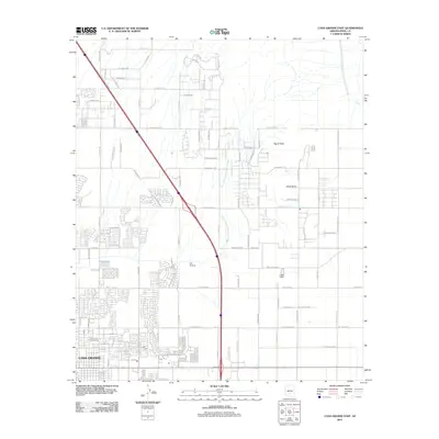
2011 Map of Casa Grande East
USGS Topo · Published 2011About this map
Casa Grande expands into the desert landscape of Pinal County in this 2011 survey, showing a transition from dense residential blocks to large-lot rural development. The urban grid, defined by streets like E Sunset Dr and E Kortsen Rd, gives way to the open terrain of the Sonoran Desert. To the east, the volcanic forms of Signal Peak and Black Butte rise above the basin floor, serving as prominent navigational landmarks. The ephemeral drainage of the North Branch Santa Cruz Wash meanders across the plain, highlighting the arid hydrological patterns of the region. Aviation history is noted by the presence of Fye Airstrip, while a sophisticated network of thoroughfares such as W Val Vista Blvd and W McCartney Rd illustrates the modern infrastructure supporting this growing Arizona community.
Find a feature on this map
79 named features on this map. Tap any name to fly to it.
Don’t see what you’re looking for? This feature index may not catch every label — zoom into the map to look around manually.
Map Details
Editions of this 2011 Casa Grande East Map
This is the sole edition of this map. No revisions or reprints were ever made.
Other maps of this area

1907 · Sacaton
USGS Topo · 1:62,500

1914 · Gila Butte
USGS Topo · 1:62,500

1917 · Gila Butte
USGS Topo · 1:62,500

1922 · Casa Grande
USGS Topo · 1:62,500

1922 · Signal Peak
USGS Topo · 1:62,500

1924 · Signal Peak
USGS Topo · 1:62,500

1924 · Casa Grande
USGS Topo · 1:62,500

1952 · Gila Butte SE
USGS Topo · 1:24,000

1952 · Gila Butte
USGS Topo · 1:62,500

1954 · Mesa
USGS Topo · 1:250,000