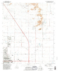
1992 Map of Casa Grande East
USGS Topo · Published 1995About this map
The Casa Grande municipality occupies the southwestern corner of this survey, showing a landscape defined by rapid mid-century growth and complex water management. Modern infrastructure like the Casa Grande Regional Medical Center and Central Arizona College sit alongside older settlement patterns and irrigation systems. The northern half of the map is dominated by the Gila River Indian Reservation, where the Sacaton Mountains rise sharply above the desert floor, featuring landmarks like Signal Peak and Black Butte.
Find a feature on this map
50 named features on this map. Tap any name to fly to it.
Don’t see what you’re looking for? This feature index may not catch every label — zoom into the map to look around manually.
Map Details
Editions of this 1992 Casa Grande East Map
This is the sole edition of this map. No revisions or reprints were ever made.
Other maps of this area

1907 · Sacaton
USGS Topo · 1:62,500

1914 · Gila Butte
USGS Topo · 1:62,500

1917 · Gila Butte
USGS Topo · 1:62,500

1922 · Casa Grande
USGS Topo · 1:62,500

1922 · Signal Peak
USGS Topo · 1:62,500

1924 · Signal Peak
USGS Topo · 1:62,500

1924 · Casa Grande
USGS Topo · 1:62,500

1952 · Gila Butte SE
USGS Topo · 1:24,000

1952 · Gila Butte
USGS Topo · 1:62,500

1954 · Mesa
USGS Topo · 1:250,000