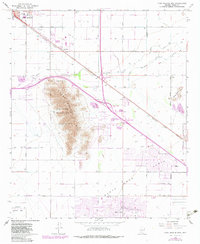
1965 Map of Casa Grande Mts
USGS Topo · Published 1983About this map
The Casa Grande Military Res and Casa Grande MTS dominate this landscape, illustrating the intersection of mid-century desert development and government land use. The urban core of Casa Grande is visible in the northwest, featuring local institutions like East Sch and the Radio Tower (KPIN). The irrigation-driven agriculture of the Pinal County desert is evident through the Casa Grande Canal and the spreading grid of the Santa Cruz Flats, which supported early 20th-century cotton and alfalfa farming. This 1982 photorevision captures the expansion of Eloy and Arizona City, highlighting the transition from purely agricultural settlements to more complex residential patterns. Key infrastructure including the Southern Pacific railroad and Interstate interchanges connect these desert outposts to the broader region, while local sites like Mtn View Cem and Casa Grande Country Club reflect the community growth during the post-war era.
Find a feature on this map
37 named features on this map. Tap any name to fly to it.
Don’t see what you’re looking for? This feature index may not catch every label — zoom into the map to look around manually.
Map Details
Editions of this 1965 Casa Grande Mts Map
3 editions found
Other maps of this area

1922 · Casa Grande
USGS Topo · 1:62,500

1922 · Signal Peak
USGS Topo · 1:62,500

1924 · Signal Peak
USGS Topo · 1:62,500

1924 · Casa Grande
USGS Topo · 1:62,500

1942 · Silver Reef Mountains
USGS Topo · 1:62,500

1947 · Eloy
USGS Topo · 1:62,500

1948 · Eloy
USGS Topo · 1:62,500

1956 · Tucson
USGS Topo · 1:250,000

1958 · Tucson
USGS Topo · 1:250,000

1959 · Tucson
USGS Topo · 1:250,000