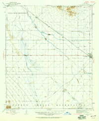
1922 Map of Casa Grande
USGS Topo · Published 1959About this map
Southern Pacific tracks and the ephemeral channels of the Santa Cruz River define the arid landscape of central Arizona in the early 1920s. This survey centers on the developing rail and irrigation corridor between the Gila River Indian Reservation and the Papago Indian Reservation. The settlement at Casa Grande is shown just as the Casa Grande Florence Canal arrived to transform the desert basin through managed water rights. Beyond the town, the map documents the critical infrastructure of the era, including the USRS Pump Sta and the intersection of the Sacaton Road and Ajo Road. Smaller outposts such as Bon, Nunez, and Chuichu provide specific points of interest for genealogists tracing early twentieth-century desert homesteads and tribal community centers.
Find a feature on this map
19 named features on this map. Tap any name to fly to it.
Don’t see what you’re looking for? This feature index may not catch every label — zoom into the map to look around manually.
Map Details
Editions of this 1922 Casa Grande Map
2 editions found
Other maps of this area

1907 · Sacaton
USGS Topo · 1:62,500

1913 · Maricopa
USGS Topo · 1:62,500

1914 · Gila Butte
USGS Topo · 1:62,500

1915 · Maricopa
USGS Topo · 1:62,500

1917 · Gila Butte
USGS Topo · 1:62,500

1922 · Casa Grande
USGS Topo · 1:62,500

1922 · Signal Peak
USGS Topo · 1:62,500

1924 · Signal Peak
USGS Topo · 1:62,500

1924 · Casa Grande
USGS Topo · 1:62,500

1941 · Vekol Mountains
USGS Topo · 1:62,500