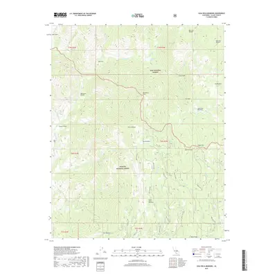
2018 Map of Casa Vieja Meadows
USGS Topo · Published 2018About this map
Jordan Hot Springs and the surrounding high-country glades define this 2018 survey of the southern Sierra Nevada range. Located within the overlapping boundaries of the Inyo National Forest and Sequoia National Forest, the landscape is characterized by a series of high-altitude clearings and meadows, such as Casa Vieja Meadows and the curiously named Beer Keg Meadow. The Kern River flows through the western portion of the quadrangle, passing through Kern Flat and Manzanita Canyon. This map details a primitive transportation network consisting primarily of US Forest Service routes like Forest Rte 20S31 and Forest Rte 21S38, which connect remote outposts and seasonal grazing areas. Notable geological features include Manzanita Knob, Doc Peak, and the prominent Blackrock Mtn in the southeast.
Find a feature on this map
54 named features on this map. Tap any name to fly to it.
Don’t see what you’re looking for? This feature index may not catch every label — zoom into the map to look around manually.
Map Details
Editions of this 2018 Casa Vieja Meadows Map
This is the sole edition of this map. No revisions or reprints were ever made.
Other maps of this area

1905 · Olancha
USGS Topo · 1:125,000

1907 · Olancha
USGS Topo · 1:125,000

1948 · Fresno
USGS Topo · 1:250,000

1955 · Fresno
USGS Topo · 1:250,000

1956 · Fresno
USGS Topo · 1:250,000

1956 · Hockett Peak
USGS Topo · 1:62,500
1956 · Monache Mtn
USGS Topo · 1:62,500

1956 · Olancha
USGS Topo · 1:62,500
1956 · Kern Peak
USGS Topo · 1:62,500

1958 · Fresno
USGS Topo · 1:250,000