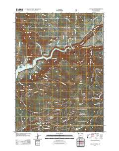
2011 Map of Cascade Gorge
USGS Topo · Published 2011About this map
Cascade Gorge serves as the focal point for this 2011 survey of the upper Rogue River corridor in Jackson County. The landscape is defined by the significant impoundment of Lost Creek Lake, which stretches through the center of the quadrangle, crossed by the Peyton Bridge. The map documents a complex water management system including the Nye Ditch and the P P & L Canal, indicating the area's historical reliance on irrigation and power infrastructure. Local genealogy interests are centered around the Nye Cemetery and Katydid Ranch, while geographic landmarks like Flounce Rock and Red Rock Canyon highlight the varied elevations of the Oregon Cascades. The settlement at Cascade Gorge sits along Mill Creek Dr, surrounded by an extensive network of forestry and access roads like Medco A Rd that penetrate the high country near Olson Mountain and Summit Prairie.
Find a feature on this map
46 named features on this map. Tap any name to fly to it.
Don’t see what you’re looking for? This feature index may not catch every label — zoom into the map to look around manually.
Map Details
Editions of this 2011 Cascade Gorge Map
This is the sole edition of this map. No revisions or reprints were ever made.
Other maps of this area

1891 · Ashland
USGS Topo · 1:250,000

1893 · Ashland
USGS Topo · 1:250,000

1897 · Ashland
USGS Topo · 1:250,000

1944 · Abbott Butte
USGS Topo · 1:62,500

1947 · Abbott Butte
USGS Topo · 1:62,500

1954 · Butte Falls
USGS Topo · 1:62,500

1955 · Rustler Peak
USGS Topo · 1:62,500

1955 · Medford
USGS Topo · 1:250,000

1956 · Prospect
USGS Topo · 1:62,500

1957 · Medford
USGS Topo · 1:250,000