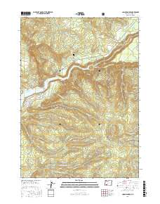
2017 Map of Cascade Gorge
USGS Topo · Published 2017About this map
Cascade Gorge and the rugged canyon of the Rogue River define this Jackson County landscape as it appeared in the late 2010s. The topography is dominated by dramatic elevation changes, notably at Skookum Gorge and Red Rock Canyon, while the southern portion features the extensive waters of Lost Cr Lake and the Peyton Reservoir. For local history researchers, the map identifies family-named sites such as Nye Cem and Nye Spring, along with the Nye Ditch irrigation feature. The infrastructure of the timber and recreation economy is evident in the dense network of forest roads, including Medco A Rd, Medco B Rd, and the Peninsula Fire Rd. Notable landmarks such as Flounce Rock, Needle Rock, and the curiously named Hole in the Ground provide clear reference points across the forested ridges of Willits Ridge and Dudley Mtn.
Find a feature on this map
65 named features on this map. Tap any name to fly to it.
Don’t see what you’re looking for? This feature index may not catch every label — zoom into the map to look around manually.
Map Details
Editions of this 2017 Cascade Gorge Map
This is the sole edition of this map. No revisions or reprints were ever made.
Other maps of this area

1891 · Ashland
USGS Topo · 1:250,000

1893 · Ashland
USGS Topo · 1:250,000

1897 · Ashland
USGS Topo · 1:250,000

1944 · Abbott Butte
USGS Topo · 1:62,500

1947 · Abbott Butte
USGS Topo · 1:62,500

1954 · Butte Falls
USGS Topo · 1:62,500

1955 · Rustler Peak
USGS Topo · 1:62,500

1955 · Medford
USGS Topo · 1:250,000

1956 · Prospect
USGS Topo · 1:62,500

1957 · Medford
USGS Topo · 1:250,000