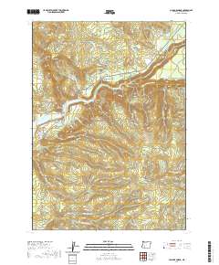
2020 Map of Cascade Gorge
USGS Topo · Published 2020About this map
Cascade Gorge sits at the heart of this Jackson County landscape, where the Rogue River and its southern fork carve through complex terrain. The northern portion of the map is defined by family-named landmarks like Nye Cem and Nye Spring, alongside agricultural infrastructure such as the Nye Ditch. Moving south, the terrain rises sharply toward Olson Mtn and Round Mtn, overlooking the Summit Prairie area. The presence of Peyton Reservoir and the Peyton Bridge crossing Lost Creek Lake suggests a managed water system and established transit points in this high-elevation region. Extensive forest and logging roads, such as Medco A Rd and the Peninsula Fire Rd, dominate the ridges, tracing a network through the Hole-in-the-Ground Cr and Red Rock Canyon drainages.
Find a feature on this map
74 named features on this map. Tap any name to fly to it.
Don’t see what you’re looking for? This feature index may not catch every label — zoom into the map to look around manually.
Map Details
Editions of this 2020 Cascade Gorge Map
This is the sole edition of this map. No revisions or reprints were ever made.
Other maps of this area

1891 · Ashland
USGS Topo · 1:250,000

1893 · Ashland
USGS Topo · 1:250,000

1897 · Ashland
USGS Topo · 1:250,000

1944 · Abbott Butte
USGS Topo · 1:62,500

1947 · Abbott Butte
USGS Topo · 1:62,500

1954 · Butte Falls
USGS Topo · 1:62,500

1955 · Rustler Peak
USGS Topo · 1:62,500

1955 · Medford
USGS Topo · 1:250,000

1956 · Prospect
USGS Topo · 1:62,500

1957 · Medford
USGS Topo · 1:250,000