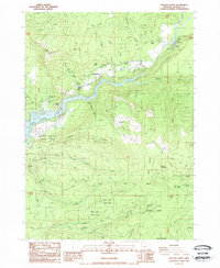
1988 Map of Cascade Gorge
USGS Topo · Published 1988About this map
The Rogue River dominates this 1988 survey of the southern Oregon landscape, showing the transition from the river's original course into the waters of Lost Creek Lake. The creation of this reservoir significantly altered the local geography, encompassing areas like the Joseph Stewart State Park and impacting the drainages of Floras Creek and Lost Creek. Infrastructure supporting the region's development is evident through the inclusion of Trans Lines, a Gaging Station, and a Radio Facility atop Flounce Rock. Local industry and land use are marked by numerous extraction sites, including a Quarry near Summit Prairie and various Borrow Pits. The map also captures several family-named landmarks and small holdings, such as Taggarts and Katydid Ranch, providing valuable points of reference for those researching late 20th-century land ownership and rural settlement patterns in Jackson County.
Find a feature on this map
45 named features on this map. Tap any name to fly to it.
Don’t see what you’re looking for? This feature index may not catch every label — zoom into the map to look around manually.
Map Details
Editions of this 1988 Cascade Gorge Map
This is the sole edition of this map. No revisions or reprints were ever made.
Other maps of this area

1891 · Ashland
USGS Topo · 1:250,000

1893 · Ashland
USGS Topo · 1:250,000

1897 · Ashland
USGS Topo · 1:250,000

1944 · Abbott Butte
USGS Topo · 1:62,500

1947 · Abbott Butte
USGS Topo · 1:62,500

1954 · Butte Falls
USGS Topo · 1:62,500

1955 · Rustler Peak
USGS Topo · 1:62,500

1955 · Medford
USGS Topo · 1:250,000

1956 · Prospect
USGS Topo · 1:62,500

1957 · Medford
USGS Topo · 1:250,000