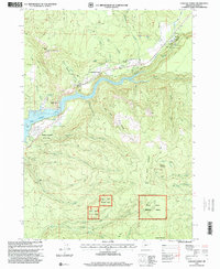
1997 Map of Cascade Gorge
USGS Topo · Published 2000About this map
The Rogue River dominates this portion of Jackson County, flowing through the dramatic Cascade Gorge and into the reservoir of Lost Creek Lake. This 1990s revision reveals a landscape defined by water management and recreational infrastructure, notably the Spillway and nearby Sewage Treatment Ponds supporting the Joseph Stewart State Park. While much of the terrain is protected within the Rogue River National Forest, industrial and utility markers like Penstocks, a Gaging Station, and multiple Power Houses indicate the river's active role in hydroelectric production.
Find a feature on this map
49 named features on this map. Tap any name to fly to it.
Don’t see what you’re looking for? This feature index may not catch every label — zoom into the map to look around manually.
Map Details
Editions of this 1997 Cascade Gorge Map
This is the sole edition of this map. No revisions or reprints were ever made.
Other maps of this area

1891 · Ashland
USGS Topo · 1:250,000

1893 · Ashland
USGS Topo · 1:250,000

1897 · Ashland
USGS Topo · 1:250,000

1944 · Abbott Butte
USGS Topo · 1:62,500

1947 · Abbott Butte
USGS Topo · 1:62,500

1954 · Butte Falls
USGS Topo · 1:62,500

1955 · Rustler Peak
USGS Topo · 1:62,500

1955 · Medford
USGS Topo · 1:250,000

1956 · Prospect
USGS Topo · 1:62,500

1957 · Medford
USGS Topo · 1:250,000