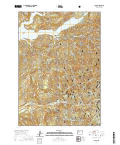
2020 Map of Cascadia
USGS Topo · Published 2020About this map
The South Santiam River winds through the heart of the Willamette National Forest, defining a landscape of dramatic elevation changes and significant water features. This 2020 survey documents the complex topography of the Cascade Range, where Green Peter Lake forms a major reservoir to the north, creating distinctive landforms like the Green Peter Peninsula and Whitcomb Island. The area is marked by several named waterfalls, including Upper Soda Falls, Lower Soda Falls, and Rainbow Falls, which highlight the steep drainage systems of creeks like Moose Cr and Dobbin Cr. Transportation across this challenging terrain is facilitated by Cascadia Dr and forest development routes such as High Deck Rd 2025, with the Garland Bridge providing a critical crossing over the river. The map also traces the prominent ridgelines of High Deck and Moose Ridge which separate the various canyon drainages.
Find a feature on this map
44 named features on this map. Tap any name to fly to it.
Don’t see what you’re looking for? This feature index may not catch every label — zoom into the map to look around manually.
Map Details
Editions of this 2020 Cascadia Map
This is the sole edition of this map. No revisions or reprints were ever made.
Other maps of this area

1929 · Mill City
USGS Topo · 1:125,000

1934 · Mc Kenzie Bridge
USGS Topo · 1:96,000

1940 · Mc Kenzie Bridge
USGS Topo · 1:125,000

1951 · Sweet Home
USGS Topo · 1:62,500

1951 · Snow Peak
USGS Topo · 1:62,500

1953 · Salem
USGS Topo · 1:250,000

1954 · Salem
USGS Topo · 1:250,000

1955 · Cascadia
USGS Topo · 1:62,500

1956 · Quartzville
USGS Topo · 1:62,500

1960 · Salem
USGS Topo · 1:250,000