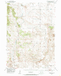
1950 Map of Casebier Hill
USGS Topo · Published 1952About this map
Old Government Farm (Historic) sits in the northern reaches of this Wyoming landscape, serving as a reminder of early agricultural efforts near the North Platte River. The terrain is characterized by a complex network of ephemeral drainages, including Cottonwood Draw, Britain Draw, and Molly Fork, which cut through the high plains toward the south. Ranching life is evident through landmarks like Meyers Ranch and several windmills scattered across the high ground between Crescent Basin and the prominent Casebier Hill. These features, mapped during the mid-century Missouri River Basin development program, illustrate a land managed for grazing and water access. The western edge is dominated by the elevations of Garnet Hill, while established thoroughfares like Fort Laramie Road and Ridge Road provided essential connectivity through this cattle country.
Find a feature on this map
15 named features on this map. Tap any name to fly to it.
Don’t see what you’re looking for? This feature index may not catch every label — zoom into the map to look around manually.
Map Details
Editions of this 1950 Casebier Hill Map
2 editions found
Other maps of this area

1896 · Patrick
USGS Topo · 1:125,000

1896 · Hartville
USGS Topo · 1:125,000

1901 · Hartville
USGS Topo · 1:125,000

1950 · Guernsey
USGS Topo · 1:24,000

1950 · Casebier Hill
USGS Topo · 1:24,000

1950 · Fort Laramie
USGS Topo · 1:24,000

1950 · Register Cliff
USGS Topo · 1:24,000

1950 · Hell Gap
USGS Topo · 1:24,000
1951 · Hell Gap
USGS Topo · 1:24,000

1951 · Moore Spring
USGS Topo · 1:24,000