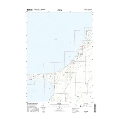
2017 Map of Caseville
USGS Topo · Published 2017About this map
The village of Caseville serves as the focal point of this coastal survey, where the Pigeon River empties into the expanse of Saginaw Bay. The landscape is defined by its transition from the structured street grid of the village, including Michigan Ave and Main St, to the marshy lowlands and small interior lakes of the shoreline. Just north of the town center, Oak Point and its associated Oak Point Lake mark a prominent geographic feature along the Lake Huron coast. This area reveals the historical layout of local cemeteries, such as the Caseville Cem and Saint Roch Roman Catholic Cem, providing valuable points of reference for genealogists. The southern reaches of the map transition into a more rural pattern of section lines and drainage, with Mud Cr and Mud Lake situated near the waters of Wild Fowl Bay, illustrating the complex hydrology of this part of Huron County.
Find a feature on this map
56 named features on this map. Tap any name to fly to it.
Don’t see what you’re looking for? This feature index may not catch every label — zoom into the map to look around manually.
Map Details
Editions of this 2017 Caseville Map
This is the sole edition of this map. No revisions or reprints were ever made.
Other maps of this area

1954 · Flint
USGS Topo · 1:250,000

1954 · Tawas City
USGS Topo · 1:250,000

1958 · Flint
USGS Topo · 1:250,000

1958 · Tawas City
USGS Topo · 1:250,000

1970 · Bay Port West
USGS Topo · 1:24,000

1970 · Bay Port East
USGS Topo · 1:24,000

1970 · Caseville
USGS Topo · 1:24,000
1970 · Rush Lake
USGS Topo · 1:24,000

1970 · Sand Point
USGS Topo · 1:24,000
1970 · Elkton
USGS Topo · 1:24,000