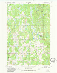
1966 Map of Casino
USGS Topo · Published 1986About this map
Casino and the neighboring settlement of Bridgeman anchor this 1966 topographic survey of central Minnesota, illustrating a landscape defined by an intricate network of wetlands and small glacial water bodies. The terrain transitions from the upland heights of Ghost Hill and Brush Hill in the north toward the meandering course of Sevenmile Creek and Rush Brook. Local genealogy is anchored by the Bridgeman Cem and a centrally located Townhall, while the presence of numerous Gravel Pits suggests the importance of local material extraction for road building during this era. The map detail highlights the specific character of the lake country, naming dozens of distinct water features including Solarz Lake, Fucat Lake, and the remote Pale Lake. This document captures the township boundaries of Meadow Brook, May, and Fairview before significant modern development, preserving the placement of rural homesteads and unimproved dirt roads.
Find a feature on this map
32 named features on this map. Tap any name to fly to it.
Don’t see what you’re looking for? This feature index may not catch every label — zoom into the map to look around manually.
Map Details
Editions of this 1966 Casino Map
2 editions found
Other maps of this area

1916 · Pillager
USGS Topo · 1:62,500

1919 · Pillager
USGS Topo · 1:62,500

1919 · Leader
USGS Topo · 1:62,500

1953 · Brainerd
USGS Topo · 1:250,000

1954 · Pillager
USGS Topo · 1:24,000

1957 · Brainerd
USGS Topo · 1:250,000

1958 · Brainerd
USGS Topo · 1:250,000

1959 · Pine River SW
USGS Topo · 1:24,000
1963 · Motley SE
USGS Topo · 1:24,000

1963 · Motley
USGS Topo · 1:24,000