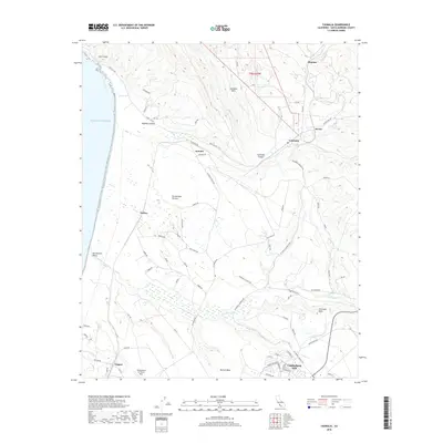
2018 Map of Casmalia
USGS Topo · Published 2018About this map
Vandenberg AFB dominates the southern landscape of this coastal quadrangle, where military infrastructure meets the rugged terrain of northern Santa Barbara County. The map details the transition from the sandy San Antonio Terrace and San Antonio Valley to the elevated reaches of the Casmalia Hills and Purisima Hills. Historic rail-stop settlements and small communities like Casmalia, Tangair, and Shuman are situated along the transit corridors that navigate the narrow canyons and coastal mesas. Along the shore, Lions Head marks a prominent point above the Pacific Ocean, while inland, the course of San Antonio Cr carves through the landscape between Burton Mesa and the surrounding heights. This era of the landscape is defined by its strategic military use and a network of named roads like Point Sal Rd and W Lompoc Casmalia Rd that connect these remote coastal outposts.
Find a feature on this map
72 named features on this map. Tap any name to fly to it.
Don’t see what you’re looking for? This feature index may not catch every label — zoom into the map to look around manually.
Map Details
Editions of this 2018 Casmalia Map
This is the sole edition of this map. No revisions or reprints were ever made.
Other maps of this area

1905 · Guadalupe
USGS Topo · 1:125,000

1905 · Lompoc
USGS Topo · 1:125,000

1942 · Point Arguello
USGS Topo · 1:62,500

1942 · Guadalupe
USGS Topo · 1:125,000

1942 · Lompoc
USGS Topo · 1:125,000

1942 · Lompoc
USGS Topo · 1:62,500

1942 · Santa Maria
USGS Topo · 1:62,500

1942 · Point Sal
USGS Topo · 1:62,500

1943 · Lompoc
USGS Topo · 1:125,000

1947 · Lompoc
USGS Topo · 1:24,000