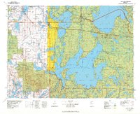
1977 Map of Cass Lake
USGS Topo · Published 1978About this map
The Mississippi River winds through this expansive landscape of the late 1970s, anchoring a region defined by its massive water bodies and dense forest reserves. To the northwest, Bemidji serves as a regional hub, featuring the State College and the Municipal Airport. The map highlights the extensive boundaries of the Leech Lake Indian Reservation, which encompasses nearly the entirety of Leech Lake, including points like Pelican Island and Sugar Point. This era shows the active Burlington Northern railroad corridor facilitating transit through the timberlands and lakeside communities. Smaller settlements such as Walker, Onigum, and Federal Dam provide crucial context for local genealogists and historians studying the lakeside economies and indigenous territories of northern Minnesota. The map also delineates several protected areas, including the Chippewa National Forest and Paul Bunyan State Forest, illustrating the balance between settlement and conservation.
Find a feature on this map
76 named features on this map. Tap any name to fly to it.
Don’t see what you’re looking for? This feature index may not catch every label — zoom into the map to look around manually.
Map Details
Editions of this 1977 Cass Lake Map
This is the sole edition of this map. No revisions or reprints were ever made.
Other maps of this area

1919 · Rosy
USGS Topo · 1:62,500

1919 · Solway
USGS Topo · 1:62,500

1919 · Max
USGS Topo · 1:62,500

1920 · Buena Vista
USGS Topo · 1:62,500

1943 · Solway
USGS Topo · 1:62,500

1953 · Duluth
USGS Topo · 1:250,000

1953 · Brainerd
USGS Topo · 1:250,000

1954 · Bemidji
USGS Topo · 1:250,000

1954 · Hibbing
USGS Topo · 1:250,000

1957 · Brainerd
USGS Topo · 1:250,000