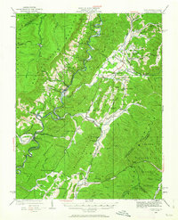
1922 Map of Cass
USGS Topo · Published 1962About this map
Cass serves as a central hub for the mountain rail economy of West Virginia in this early 1920s survey. The landscape is defined by the steep ridges of Cheat Mountain and Allegheny Mountain, where the industrial presence of the Lumber RR winds through high-altitude timber stands near the remote settlement of Spruce. Along the valley floor, the Greenbrier River dictates the path of the Chesapeake & Ohio RR, connecting smaller riverside communities like Hosterman and Stony Bottom.
Find a feature on this map
116 named features on this map. Tap any name to fly to it.
Don’t see what you’re looking for? This feature index may not catch every label — zoom into the map to look around manually.
Map Details
Editions of this 1922 Cass Map
4 editions found

Other maps of this area

1889 · Beverly
USGS Topo · 1:125,000

1891 · Huntersville
USGS Topo · 1:125,000

1892 · Beverly
USGS Topo · 1:125,000

1893 · Buckhannon
USGS Topo · 1:125,000

1894 · Huntersville
USGS Topo · 1:125,000

1896 · Buckhannon
USGS Topo · 1:125,000

1897 · Buckhannon
USGS Topo · 1:125,000

1901 · Monterey
USGS Topo · 1:125,000

1913 · Pickens
USGS Topo · 1:48,000

1915 · Pickens
USGS Topo · 1:62,500