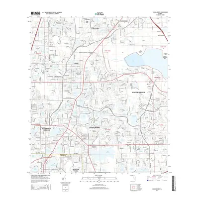
2015 Map of Casselberry
USGS Topo · Published 2015About this map
Casselberry and Winter Springs form a dense corridor of lakes and residential expansion in this mid-2010s survey of Seminole and Orange Counties. The landscape is defined by its remarkable density of freshwater bodies, ranging from the expansive Lake Jesup in the northeast to smaller urban lakes like Lake Fairy and Lake Wildmere. This era shows a fully matured suburban infrastructure, where education and specialized training centers like the Seminole Community College and the Golf Academy of America are integrated into the neighborhood fabric. Significant recreational and natural corridors are preserved amidst the development, most notably the Florida National Scenic Trail, which winds through the area. Local history is anchored by established communities like Longwood and Lake Mary, while legacy names such as Mecca Hammock and Eureka Hammock hint at the original subtropical terrain that predated the late-20th-century growth.
Find a feature on this map
101 named features on this map. Tap any name to fly to it.
Don’t see what you’re looking for? This feature index may not catch every label — zoom into the map to look around manually.
Map Details
Editions of this 2015 Casselberry Map
This is the sole edition of this map. No revisions or reprints were ever made.
Other maps of this area

1953 · Oviedo SW
USGS Topo · 1:24,000

1955 · Orlando
USGS Topo · 1:250,000

1956 · Oviedo
USGS Topo · 1:24,000

1956 · Orlando West
USGS Topo · 1:24,000

1956 · Orlando East
USGS Topo · 1:24,000

1957 · Orlando
USGS Topo · 1:250,000

1958 · Orlando
USGS Topo · 1:250,000

1959 · Forest City
USGS Topo · 1:24,000

1962 · Orlando
USGS Topo · 1:250,000

1962 · Casselberry
USGS Topo · 1:24,000