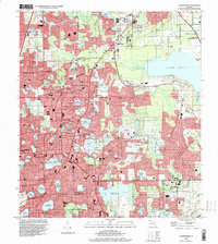
1994 Map of Casselberry
USGS Topo · Published 2000About this map
Casselberry and the surrounding central Florida lake country appear here in a period of significant suburban expansion, where residential development heavily integrates with the local hydrology. The map illustrates a dense concentration of water bodies, from the expansive Lake Jesup in the northeast to smaller interior lakes like Lake Wildmere, Lake Kathryn, and Fairy Lake. This hydrological network is punctuated by civic institutions such as the Lyman High Sch and Rosenwald Sch, alongside numerous community landmarks like Mt Olive Ch and the Ebenezer Ch. Significant conservation and recreation areas are also visible, including the Lake Jesup Conservation Area and Big Tree Park. The transition from the rural hammocks like Mecca Hammock to the organized grids of Longwood and Altamonte Springs highlights the 1990s character of Seminole County.
Find a feature on this map
97 named features on this map. Tap any name to fly to it.
Don’t see what you’re looking for? This feature index may not catch every label — zoom into the map to look around manually.
Map Details
Editions of this 1994 Casselberry Map
This is the sole edition of this map. No revisions or reprints were ever made.
Other maps of this area

1953 · Oviedo SW
USGS Topo · 1:24,000

1955 · Orlando
USGS Topo · 1:250,000

1956 · Oviedo
USGS Topo · 1:24,000

1956 · Orlando West
USGS Topo · 1:24,000

1956 · Orlando East
USGS Topo · 1:24,000

1957 · Orlando
USGS Topo · 1:250,000

1958 · Orlando
USGS Topo · 1:250,000

1959 · Forest City
USGS Topo · 1:24,000

1962 · Orlando
USGS Topo · 1:250,000

1962 · Casselberry
USGS Topo · 1:24,000