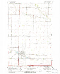
1961 Map of Casselton
USGS Topo · Published 1986About this map
The railroad town of Casselton dominates the southern landscape of this Cass County survey, serving as a critical junction for the Great Northern and Northern Pacific railroads. This network of steel defines the local economy and settlement pattern, extending into neighboring townships like Everest, Durbin, and Harmony. The topography is shaped by the wandering paths of Swan Creek and the Rush River, which carve through the flat agricultural expanse of the Red River Valley.
Find a feature on this map
20 named features on this map. Tap any name to fly to it.
Don’t see what you’re looking for? This feature index may not catch every label — zoom into the map to look around manually.
Map Details
Editions of this 1961 Casselton Map
2 editions found
Other maps of this area

1895 · Casselton
USGS Topo · 1:125,000

1897 · Casselton
USGS Topo · 1:125,000

1952 · Grand Forks
USGS Topo · 1:250,000

1953 · Fargo
USGS Topo · 1:250,000

1956 · Fargo
USGS Topo · 1:250,000

1956 · Grand Forks
USGS Topo · 1:250,000

1961 · Durbin
USGS Topo · 1:24,000

1961 · Casselton
USGS Topo · 1:24,000
1961 · Casselton SE
USGS Topo · 1:24,000
1961 · Mapleton
USGS Topo · 1:24,000