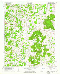
1960 Map of Cassville
USGS Topo · Published 1961About this map
Walker Mountain and the complex ridges of Spring Mountain dominate this White County landscape, where traditional rural life in the early 1960s centered around numerous small country churches and family cemeteries. The historical presence of the Old Kentucky Road bisecting the northern half of the map speaks to the area's long-established transit corridors, while more localized routes like Carthage Road and Ferry Road connect dispersed settlements. Genealogy researchers will find significant value in the density of burial grounds, including the Black Oak Cems and Ward Cem, alongside local landmarks like Hutchins College and Panchers Mills. The terrain is marked by geological features like Rockhouse Cave and Boiling Pond, illustrating a landscape defined by its karst topography and the winding drainages of Cane Creek and Gleason Creek.
Find a feature on this map
65 named features on this map. Tap any name to fly to it.
Don’t see what you’re looking for? This feature index may not catch every label — zoom into the map to look around manually.
Map Details
Editions of this 1960 Cassville Map
3 editions found
Other maps of this area

1892 · Pikeville
USGS Topo · 1:125,000

1893 · Mc Minnville
USGS Topo · 1:125,000

1895 · Mc Minnville
USGS Topo · 1:125,000

1895 · Pikeville
USGS Topo · 1:125,000

1897 · Standingstone
USGS Topo · 1:125,000

1898 · Standingstone
USGS Topo · 1:125,000

1943 · Cookeville
USGS Topo · 1:100,000

1944 · Cookeville
USGS Topo · 1:100,000

1953 · Chattanooga
USGS Topo · 1:250,000

1954 · Sparta
USGS Topo · 1:24,000