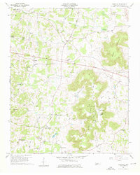
1960 Map of Cassville
USGS Topo · Published 1976About this map
Fanchers Mills and the surrounding rural communities of White County appear here during a period of steady agrarian development in the mid-20th century. The landscape is defined by the prominent ridge of Walker Mountain and the significant elevations of Spring Mountain, which separate the valley floor from the dissected terrain of Cashdollar Cove and Carrick Cove. The mapping provides a detailed look at the rural infrastructure of the era, recording numerous country churches such as Wesley Chapel and Hensley Chapel, along with local educational landmarks like Hutchins College and Central View Sch. Historical transportation routes, including the Kentucky Road and Carthage Road, underscore the region's connectivity before modern highway expansions. Water features like Boiling Pond and Gum Spring indicate the limestone-rich geology that also formed Rockhouse Cave, offering insights into the local environment that sustained these upland settlements.
Find a feature on this map
61 named features on this map. Tap any name to fly to it.
Don’t see what you’re looking for? This feature index may not catch every label — zoom into the map to look around manually.
Map Details
Editions of this 1960 Cassville Map
3 editions found
Other maps of this area

1892 · Pikeville
USGS Topo · 1:125,000

1893 · Mc Minnville
USGS Topo · 1:125,000

1895 · Mc Minnville
USGS Topo · 1:125,000

1895 · Pikeville
USGS Topo · 1:125,000

1897 · Standingstone
USGS Topo · 1:125,000

1898 · Standingstone
USGS Topo · 1:125,000

1943 · Cookeville
USGS Topo · 1:100,000

1944 · Cookeville
USGS Topo · 1:100,000

1953 · Chattanooga
USGS Topo · 1:250,000

1954 · Sparta
USGS Topo · 1:24,000