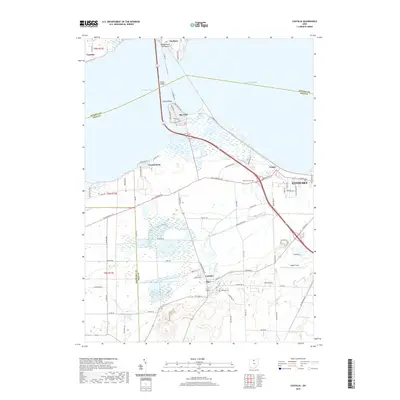
2019 Map of Castalia
USGS Topo · Published 2019About this map
Castalia serves as a focal point in this 2019 survey, situated near the headwaters of Cold Cr and the famous Blue Hole. The landscape is defined by the transition from the high ground of northern Ohio toward the marshy margins of Sandusky Bay. To the north, the Edison Bridge spans the bay to reach the Marblehead Peninsula, connecting the mainland to Danbury and Gypsum. The map details the residential expansion west of Sandusky, including the communities of Venice and Bay View along the shoreline. Researchers will find significant local history sites such as Oak Lawn Cem and Castalia Cem, alongside aviation landmarks like Mather Field. The intricate drainage patterns of Mills Cr and Little Pickerel Cr illustrate the complex hydrology of Erie and Sandusky Counties as they feed into Lake Erie.
Find a feature on this map
75 named features on this map. Tap any name to fly to it.
Don’t see what you’re looking for? This feature index may not catch every label — zoom into the map to look around manually.
Map Details
Editions of this 2019 Castalia Map
This is the sole edition of this map. No revisions or reprints were ever made.
Other maps of this area

1901 · Put-In-Bay
USGS Topo · 1:62,500

1901 · Bellevue
USGS Topo · 1:62,500

1903 · Bellevue
USGS Topo · 1:62,500

1903 · Put In Bay
USGS Topo · 1:62,500

1904 · Sandusky
USGS Topo · 1:62,500

1916 · Kelleys Island
USGS Topo · 1:62,500

1919 · Kelleys Island
USGS Topo · 1:62,500

1956 · Toledo
USGS Topo · 1:250,000

1957 · Vickery
USGS Topo · 1:24,000

1959 · Kimball
USGS Topo · 1:24,000