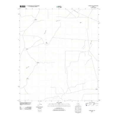
2010 Map of Castile Hill
USGS Topo · Published 2010About this map
Castile Hill rises over a landscape defined by the essential infrastructure of West Texas ranching. This arid terrain in Culberson County is sparsely populated, yet it is marked by a network of water sources vital to the region's cattle industry. Named features like the Delaware Windmill, Antelope Windmill, and Bowman Windmill highlight the reliance on groundwater in an area where surface water is limited to seasonal channels. Drainage patterns are established by Castile Draw and Kimbell Draw, which navigate the wide expanse of Sink Hole Flat. Modern transportation is represented by FM 652 cutting across the northern reaches, connecting these remote outposts. The distribution of these specific, named windmills offers a clear look at the spatial organization of range land in the early 21st century.
Find a feature on this map
11 named features on this map. Tap any name to fly to it.
Don’t see what you’re looking for? This feature index may not catch every label — zoom into the map to look around manually.
Map Details
Editions of this 2010 Castile Hill Map
This is the sole edition of this map. No revisions or reprints were ever made.
Other maps of this area

1954 · Van Horn
USGS Topo · 1:250,000

1958 · Van Horn
USGS Topo · 1:250,000

1973 · Seven L Peak
USGS Topo · 1:24,000

1973 · Owl Hills
USGS Topo · 1:24,000

1973 · Seven L Peak NE
USGS Topo · 1:24,000

1973 · Rustler Hills
USGS Topo · 1:24,000

1973 · Screw Bean Draw West
USGS Topo · 1:24,000

1973 · Delaware Spring
USGS Topo · 1:24,000
1973 · Castile Hill
USGS Topo · 1:24,000
1973 · Outlaw Spring
USGS Topo · 1:24,000