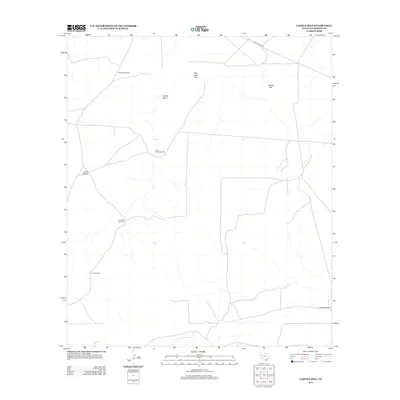
2012 Map of Castile Hill
USGS Topo · Published 2012About this map
Castile Hill rises above the arid terrain of Culberson County, defining a landscape marked by essential water infrastructure in the Chihuahuan Desert. The placement of named landmarks like Delaware Windmill, Shorty Windmill, and Little Castile Windmill reveals a specialized ranching geography where survival depends on these specific, mapped points of extraction. The presence of Sink Hole Flat and the drainage of Castile Draw provide evidence of the unique geological features and occasional hydrological activity that shape this corner of West Texas. Connectivity to the broader region is maintained via Ranch Road 652 in the north, while a network of local roads links remote sites such as Antelope Windmill and Bowman Windmill, highlighting the spatial organization of land use and livestock management in the early 21st century.
Find a feature on this map
10 named features on this map. Tap any name to fly to it.
Don’t see what you’re looking for? This feature index may not catch every label — zoom into the map to look around manually.
Map Details
Editions of this 2012 Castile Hill Map
This is the sole edition of this map. No revisions or reprints were ever made.
Other maps of this area

1954 · Van Horn
USGS Topo · 1:250,000

1958 · Van Horn
USGS Topo · 1:250,000

1973 · Seven L Peak
USGS Topo · 1:24,000

1973 · Owl Hills
USGS Topo · 1:24,000

1973 · Seven L Peak NE
USGS Topo · 1:24,000

1973 · Rustler Hills
USGS Topo · 1:24,000

1973 · Screw Bean Draw West
USGS Topo · 1:24,000

1973 · Delaware Spring
USGS Topo · 1:24,000
1973 · Castile Hill
USGS Topo · 1:24,000
1973 · Outlaw Spring
USGS Topo · 1:24,000