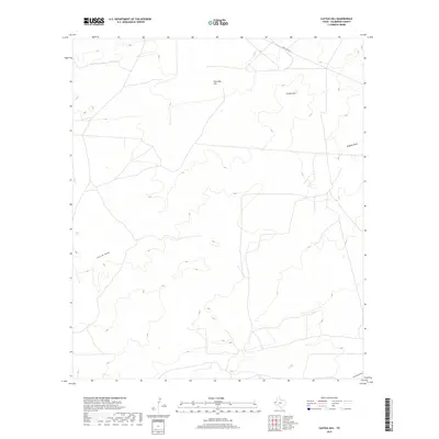
2019 Map of Castile Hill
USGS Topo · Published 2019About this map
Castile Hill and the surrounding high desert of Culberson County define this corner of the Trans-Pecos region. The landscape is marked by the distinct drainage patterns of ephemeral watercourses, including Castile Draw and Kimbell Draw, which channel runoff through the arid terrain. Sink Hole Flat suggests the underlying geological complexity of the area, where subterranean processes have influenced the surface topography. Transportation through this isolated stretch of West Texas is primarily facilitated by Ranch Rd 652, providing a vital corridor for those navigating between regional landmarks. The map illustrates a segment of the Chihuahuan Desert where traditional ranching and modern resource management intersect, evidenced by the network of draws like Horseshoe Draw that cross the sparse landscape.
Find a feature on this map
6 named features on this map. Tap any name to fly to it.
Don’t see what you’re looking for? This feature index may not catch every label — zoom into the map to look around manually.
Map Details
Editions of this 2019 Castile Hill Map
This is the sole edition of this map. No revisions or reprints were ever made.
Other maps of this area

1954 · Van Horn
USGS Topo · 1:250,000

1958 · Van Horn
USGS Topo · 1:250,000

1973 · Seven L Peak
USGS Topo · 1:24,000

1973 · Owl Hills
USGS Topo · 1:24,000

1973 · Seven L Peak NE
USGS Topo · 1:24,000

1973 · Rustler Hills
USGS Topo · 1:24,000

1973 · Screw Bean Draw West
USGS Topo · 1:24,000

1973 · Delaware Spring
USGS Topo · 1:24,000
1973 · Castile Hill
USGS Topo · 1:24,000
1973 · Outlaw Spring
USGS Topo · 1:24,000