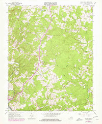
1966 Map of Castle Craig
USGS Topo · Published 1978About this map
The Big Otter River winds through the southern landscape of this region, meeting with Cheese Creek near the border of Roanoke Co and Pittsylvania Co. This mid-century survey, updated in the late 1970s, reveals a rural network of small communities and crossroads anchored by historical congregations. Small settlements like Kingston and Castle Craig appear as clusters of homes and services along the primary north-south corridors, while the surrounding Hills are dotted with numerous churches including Chapel Grove Ch, Liberty Ch, and New Hope Ch. The drainage patterns of Seneca Creek and its tributaries define the local geography, providing a clear look at the area's development before more modern expansion. Local landmarks such as Altavista Memorial Park and Seminole Lake offer specific points of interest for genealogists tracing family ties to these Virginia townships.
Find a feature on this map
28 named features on this map. Tap any name to fly to it.
Don’t see what you’re looking for? This feature index may not catch every label — zoom into the map to look around manually.
Map Details
Editions of this 1966 Castle Craig Map
3 editions found
Other maps of this area

1892 · Lynchburg
USGS Topo · 1:125,000

1944 · Lynchburg
USGS Topo · 1:62,500

1947 · Roanoke
USGS Topo · 1:250,000

1950 · Goode
USGS Topo · 1:62,500

1950 · Lynchburg
USGS Topo · 1:62,500

1951 · Altavista
USGS Topo · 1:62,500

1956 · Gladys
USGS Topo · 1:62,500

1959 · Roanoke
USGS Topo · 1:250,000

1963 · Roanoke
USGS Topo · 1:250,000

1963 · City Farm
USGS Topo · 1:24,000