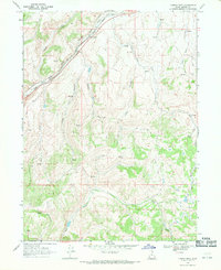
1968 Map of Castle Rock
USGS Topo · Published 1971About this map
Castle Rock sits at the junction of narrow valleys and high ridges in Summit County, where the infrastructure of the Union Pacific railroad carves through the terrain. This late-1960s survey documents a landscape defined by its drainages, including the prominent Echo Creek and Huff Creek systems. The map captures a transition in backcountry access, shown through numerous Jeep Trails that spiderweb across the canyons to reach various Springs and isolated landmarks like a Corral or a lone Drill Hole. The naming conventions of the canyons, such as Ellis Canyon and Stag Canyon, reflect the area's geography and history. The presence of Tristram Creek and Rees Creek further delineates the complex watershed of this high mountain region, providing a detailed view of the water sources vital for ranching and transport in this part of northern Utah.
Find a feature on this map
21 named features on this map. Tap any name to fly to it.
Don’t see what you’re looking for? This feature index may not catch every label — zoom into the map to look around manually.
Map Details
Editions of this 1968 Castle Rock Map
3 editions found
Other maps of this area

1885 · Salt Lake
USGS Topo · 1:250,000

1900 · Coalville
USGS Topo · 1:125,000

1903 · Coalville
USGS Topo · 1:125,000

1954 · Salt Lake City
USGS Topo · 1:250,000

1954 · Ogden
USGS Topo · 1:250,000

1958 · Ogden
USGS Topo · 1:250,000

1958 · Salt Lake City
USGS Topo · 1:250,000

1960 · Ogden
USGS Topo · 1:250,000

1960 · Salt Lake City
USGS Topo · 1:250,000

1964 · Francis Canyon
USGS Topo · 1:24,000