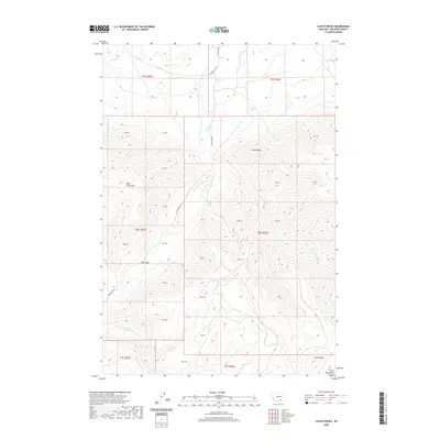
2020 Map of Castle Rocks
USGS Topo · Published 2020About this map
Pryor Gap serves as a prominent natural passage through the high-elevation terrain of Big Horn County, as documented by the United States Geological Survey. This 2020 topographic record highlights the complex relief of West Pryor Mtn and the namesake Castle Rocks formation, which dominate the central landscape. The area is defined by sharp elevation shifts between ridges and the drainage basins of Pryor Cr and Bird Cr, illustrating the importance of natural corridors in this part of the Pryor Mountains. Historical water management is evident in the presence of the Lost Cr Ditch, while modern connectivity is maintained by Pryor Gap Rd. Further south, Crown Butte stands as a distinct landmark near Summit Cr, marking the rugged transition towards the southern reaches of the range.
Find a feature on this map
16 named features on this map. Tap any name to fly to it.
Don’t see what you’re looking for? This feature index may not catch every label — zoom into the map to look around manually.
Map Details
Editions of this 2020 Castle Rocks Map
This is the sole edition of this map. No revisions or reprints were ever made.
Other maps of this area

1954 · Billings
USGS Topo · 1:250,000

1957 · Billings
USGS Topo · 1:250,000

1958 · Billings
USGS Topo · 1:250,000

1964 · Big Ice Cave
USGS Topo · 1:24,000

1967 · Castle Rocks
USGS Topo · 1:24,000

1967 · Deep Creek
USGS Topo · 1:24,000

1967 · Pryor
USGS Topo · 1:24,000

1967 · Deep Creek SW
USGS Topo · 1:24,000

1967 · Section House Draw
USGS Topo · 1:24,000
1967 · Pryor NW
USGS Topo · 1:24,000