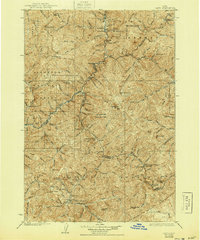
1930 Map of Casto
USGS Topo · Published 1944About this map
Mining operations and isolated mountain ranches define this central Idaho landscape in the late 1920s. The convergence of four different national forests—Salmon, Challis, Payette, and Idaho—demonstrates the vast wilderness management of the era. Settlement is sparse, appearing primarily as family-named outposts such as Falconberry Ranch, Ramey Ranch, and Boyle Ranch, often situated near life-sustaining water sources like Warm Spring Creek or the Middle Fork.
Find a feature on this map
114 named features on this map. Tap any name to fly to it.
Don’t see what you’re looking for? This feature index may not catch every label — zoom into the map to look around manually.
Map Details
Editions of this 1930 Casto Map
2 editions found
Other maps of this area

1891 · Bear Valley
USGS Topo · 1:125,000

1893 · Bear Valley
USGS Topo · 1:125,000

1919 · Custer
USGS Topo · 1:125,000

1922 · Custer
USGS Topo · 1:125,000

1929 · Bayhorse
USGS Topo · 1:125,000

1930 · Casto
USGS Topo · 1:125,000

1950 · Blackbird Mtn
USGS Topo · 1:62,500

1951 · Blackbird Mtn
USGS Topo · 1:62,500

1956 · Twin Peaks
USGS Topo · 1:62,500

1956 · Elk City
USGS Topo · 1:250,000