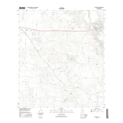
2016 Map of Castroville
USGS Topo · Published 2016About this map
Castroville and the surrounding Medina County landscape are defined by a complex network of waterways and irrigation infrastructure, including the prominent Medina Irrigation Canal and the meandering Medina River. To the west, the settlement of Dunlay sits amidst a grid of country roads, while the central terrain is marked by distinctive elevations like Clousley Hill and California Hill. This map details the local water management system, showing how Chacon Cr feeds into the Chacon Reservoir at the southern edge of the quadrangle.
Find a feature on this map
104 named features on this map. Tap any name to fly to it.
Don’t see what you’re looking for? This feature index may not catch every label — zoom into the map to look around manually.
Map Details
Editions of this 2016 Castroville Map
This is the sole edition of this map. No revisions or reprints were ever made.
Other maps of this area

1942 · Natalia
USGS Topo · 1:62,500

1954 · San Antonio
USGS Topo · 1:250,000

1956 · New Fountain
USGS Topo · 1:62,500

1957 · San Antonio
USGS Topo · 1:250,000

1958 · La Coste
USGS Topo · 1:24,000

1958 · La Coste NE
USGS Topo · 1:24,000

1964 · Riomedina
USGS Topo · 1:24,000

1964 · Castroville
USGS Topo · 1:24,000

1964 · Devine
USGS Topo · 1:24,000
1964 · Lytle
USGS Topo · 1:24,000