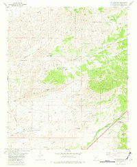
1981 Map of Cat Mountain
USGS Topo · Published 1982About this map
The Mescalero Apache Indian Reservation dominates the northern and eastern portions of this landscape, where the high desert terrain meets the rugged foothills of the Sacramento Mountains. Life in this arid region is defined by the scattered water sources vital to ranching and local history, including Maxwell Spring, Baca Spring, and the White Flat Tank located near the center of the sheet. The map reveals a network of primitive transportation, with various Jeep Trails navigating the slopes between Cat Mountain and Coyote Peak. To the south, Tularosa Creek provides a focal point for the terrain, featuring a Gaging Sta and nearby Apodaca Spring. Numerous Prospects and Prospect markings pepper the canyons such as Coyote Canyon and Dry Canyon, indicating the region's history of mineral exploration.
Find a feature on this map
35 named features on this map. Tap any name to fly to it.
Don’t see what you’re looking for? This feature index may not catch every label — zoom into the map to look around manually.
Map Details
Editions of this 1981 Cat Mountain Map
This is the sole edition of this map. No revisions or reprints were ever made.
Other maps of this area

1916 · Tularosa
USGS Topo · 1:125,000

1947 · Three Rivers
USGS Topo · 1:62,500

1948 · Tularosa
USGS Topo · 1:62,500

1950 · Three Rivers
USGS Topo · 1:24,000

1950 · Sierra Blanca Peak
USGS Topo · 1:62,500

1950 · Mescalero
USGS Topo · 1:62,500

1954 · Tularosa
USGS Topo · 1:250,000

1955 · Roswell
USGS Topo · 1:250,000

1958 · Roswell
USGS Topo · 1:250,000

1958 · Tularosa
USGS Topo · 1:250,000