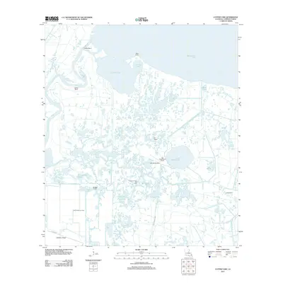
2012 Map of Catfish Lake
USGS Topo · Published 2012About this map
Mermentau River and Catfish Lake dominate this coastal landscape of Cameron Parish, where the complex hydrology of southwestern Louisiana is on full display. The geography is a dense network of bayous, lakes, and ridges, punctuated by industrial infrastructure and isolated landmarks. Natural features like Locust Bay and Tebo Point sit adjacent to evidence of resource extraction, such as the Garnd Chenier Gas Field and Go Around Bayou Gas Field. Human activity in this marshy environment is specifically adapted to the terrain, evidenced by the Little Pecan Island Airport and the Dr Miller Canal. To the south, Hackberry Ridge and the T T Mhire Rd provide a corridor of solid ground through the surrounding wetlands, while inland islands like Elm Island and Little Pecan Island rise above the interconnected waters of Little Pecan Lake and its associated canals.
Find a feature on this map
24 named features on this map. Tap any name to fly to it.
Don’t see what you’re looking for? This feature index may not catch every label — zoom into the map to look around manually.
Map Details
Editions of this 2012 Catfish Lake Map
This is the sole edition of this map. No revisions or reprints were ever made.
Other maps of this area

1932 · Constance Bayou NW
USGS Topo · 1:31,680

1934 · Catfish Lake
USGS Topo · 1:24,000

1934 · Lake Misere
USGS Topo · 1:24,000

1934 · Latania Lake
USGS Topo · 1:24,000

1935 · Lake Misere
USGS Topo · 1:31,680

1935 · Catfish Lake
USGS Topo · 1:31,680

1935 · Latania Lake
USGS Topo · 1:31,680

1935 · Grand Chenier
USGS Topo · 1:31,680

1946 · Hog Bayou NE
USGS Topo · 1:31,680

1946 · Hog Bayou NW
USGS Topo · 1:31,680