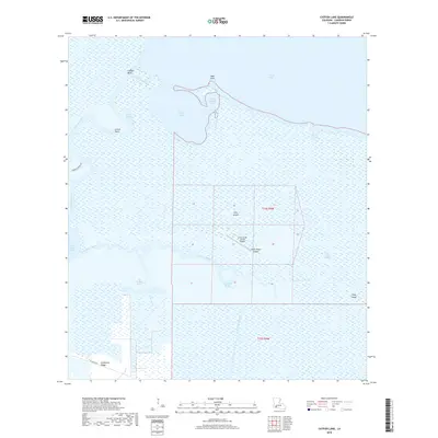
2018 Map of Catfish Lake
USGS Topo · Published 2018About this map
Little Pecan Island sits within a complex network of wetlands and tidal channels in this 2018 coastal survey. The map reveals a landscape dominated by the Mermentau River and expansive water bodies like Catfish Lake and Grand Lake. A notable human imprint on this remote terrain is the Little Pecan Island Airport, situated on a thin strip of higher ground alongside Elm Island. The intricate hydrography includes curiously named features such as Go Around Bayou and Cut Around Bayou, which suggest the navigational challenges of the Chenier Plain. Toward the southwest, Hackberry Ridge provides one of the few named topographic breaks in an otherwise fluid environment of marshes and canals like the Dr Miller Canal. This document serves as a detailed record of the contemporary Louisiana coastline, showing the fragile balance between land and water in Cameron Parish.
Find a feature on this map
27 named features on this map. Tap any name to fly to it.
Don’t see what you’re looking for? This feature index may not catch every label — zoom into the map to look around manually.
Map Details
Editions of this 2018 Catfish Lake Map
This is the sole edition of this map. No revisions or reprints were ever made.
Other maps of this area

1932 · Constance Bayou NW
USGS Topo · 1:31,680

1934 · Catfish Lake
USGS Topo · 1:24,000

1934 · Lake Misere
USGS Topo · 1:24,000

1934 · Latania Lake
USGS Topo · 1:24,000

1935 · Lake Misere
USGS Topo · 1:31,680

1935 · Catfish Lake
USGS Topo · 1:31,680

1935 · Latania Lake
USGS Topo · 1:31,680

1935 · Grand Chenier
USGS Topo · 1:31,680

1946 · Hog Bayou NE
USGS Topo · 1:31,680

1946 · Hog Bayou NW
USGS Topo · 1:31,680