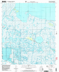
1998 Map of Catfish Lake
USGS Topo · Published 2003About this map
Grand Lake and the vast marshlands of the Mermentau River delta define this late-20th-century survey of the Louisiana coast. The landscape is a complex network of waterways and low-lying cheniers, where the terrestrial and aquatic worlds blur. Notable human activity is centered on Hackberry Ridge and Little Pecan Island, the latter of which features the Little Pecan Island Landing Strip, indicating the area's importance for remote access and coastal resource management.
Find a feature on this map
27 named features on this map. Tap any name to fly to it.
Don’t see what you’re looking for? This feature index may not catch every label — zoom into the map to look around manually.
Map Details
Editions of this 1998 Catfish Lake Map
This is the sole edition of this map. No revisions or reprints were ever made.
Other maps of this area

1932 · Constance Bayou NW
USGS Topo · 1:31,680

1934 · Catfish Lake
USGS Topo · 1:24,000

1934 · Lake Misere
USGS Topo · 1:24,000

1934 · Latania Lake
USGS Topo · 1:24,000

1935 · Lake Misere
USGS Topo · 1:31,680

1935 · Catfish Lake
USGS Topo · 1:31,680

1935 · Latania Lake
USGS Topo · 1:31,680

1935 · Grand Chenier
USGS Topo · 1:31,680

1946 · Hog Bayou NE
USGS Topo · 1:31,680

1946 · Hog Bayou NW
USGS Topo · 1:31,680