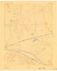
1893 Map of Catlin
USGS Topo · Published 1910About this map
The high plains of Otero County appear here in their late 19th-century state, dominated by the parallel courses of the Arkansas River and the competing steel lines of the Atchison Topeka and Santa Fe Railroad. The settlement at Rocky Ford emerges as a primary center of activity along the river, while the Missouri Pacific Railroad cuts a straight path further north through the arid uplands, stopping at small sidings and outposts like Numa, Olney, and Meredith.
Find a feature on this map
30 named features on this map. Tap any name to fly to it.
Don’t see what you’re looking for? This feature index may not catch every label — zoom into the map to look around manually.
Map Details
Editions of this 1893 Catlin Map
5 editions found

Other maps of this area

1889 · Sanborn
USGS Topo · 1:125,000

1891 · Sanborn
USGS Topo · 1:125,000

1891 · Catlin
USGS Topo · 1:125,000

1891 · Arroyo
USGS Topo · 1:125,000

1891 · Higbee
USGS Topo · 1:125,000

1891 · Las Animas
USGS Topo · 1:125,000

1891 · Timpas
USGS Topo · 1:125,000

1891 · Nepesta
USGS Topo · 1:125,000

1891 · Apishapa
USGS Topo · 1:125,000

1893 · Arroyo
USGS Topo · 1:125,000