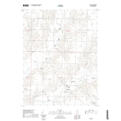
2019 Map of Catlin
USGS Topo · Published 2019About this map
Little Raccoon Creek and its many tributaries carve a winding path through this portion of Parke County, a landscape defined by its historic stream crossings. This region is notable for its concentration of structural heritage, featuring numerous timber spans including Crooks Covered Bridge, McAllisters Covered Bridge, and Neet Covered Bridge. The map captures the small-town layout of Bridgeton, situated where Big Raccoon Creek meets Clear Run, and shows the quiet settlements of Catlin and Minshall nestled among the drainage basins of Molasses Cr and Lakeys Br. For genealogists, several family-named burial sites are documented across the rural sections, such as Hartman Family Cem and the Adams Lee Cem. The terrain transitions from the open bottomlands of Pleasant Valley to more dissected areas like Happy Hollow, reflecting the enduring agricultural and hydraulic patterns of Western Indiana.
Find a feature on this map
83 named features on this map. Tap any name to fly to it.
Don’t see what you’re looking for? This feature index may not catch every label — zoom into the map to look around manually.
Map Details
Editions of this 2019 Catlin Map
This is the sole edition of this map. No revisions or reprints were ever made.
Other maps of this area

1950 · Rosedale
USGS Topo · 1:24,000

1950 · Brazil East
USGS Topo · 1:24,000

1950 · Brazil West
USGS Topo · 1:24,000

1951 · Mecca
USGS Topo · 1:24,000

1951 · Mansfield
USGS Topo · 1:24,000

1952 · Catlin
USGS Topo · 1:24,000

1953 · Indianapolis
USGS Topo · 1:250,000

1955 · Rockville
USGS Topo · 1:24,000

1955 · Montezuma
USGS Topo · 1:24,000

1956 · Indianapolis
USGS Topo · 1:250,000