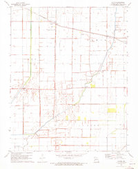
1971 Map of Catron
USGS Topo · Published 1973About this map
The agricultural landscape of New Madrid County is defined here by a network of drainage ditches and the meandering course of the Little River. In the early 1970s, the village of Catron served as a local hub, situated at the junction of the St Louis Southwestern railroad and a prominent Radio Tower. The map illustrates a transition in land use, featuring both the engineered precision of the Old Channel and the persistent small-town footprints of Baderville, Dodds, and Lone Star. Evidence of local infrastructure is scattered across the townships of Como, Lewis, and La Font, including a Gaging Station and a rural Landing Strip. The presence of a Sewage Disposal Pond and the Sl - Sf railroad line in the southern reaches further documents the mid-century development of this Missouri Bootheel region.
Find a feature on this map
15 named features on this map. Tap any name to fly to it.
Don’t see what you’re looking for? This feature index may not catch every label — zoom into the map to look around manually.
Map Details
Editions of this 1971 Catron Map
This is the sole edition of this map. No revisions or reprints were ever made.
Other maps of this area

1939 · Portageville
USGS Topo · 1:62,500

1939 · New Madrid
USGS Topo · 1:62,500

1940 · Malden
USGS Topo · 1:62,500

1940 · Pascola
USGS Topo · 1:62,500

1951 · New Madrid SE
USGS Topo · 1:24,000

1954 · New Madrid
USGS Topo · 1:62,500

1955 · Pascola
USGS Topo · 1:62,500

1955 · Portageville
USGS Topo · 1:62,500

1956 · Malden
USGS Topo · 1:62,500

1956 · Dyersburg
USGS Topo · 1:250,000