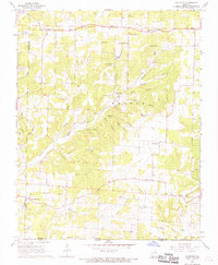
1968 Map of Caulfield
USGS Topo · Published 1968About this map
Caulfield and the surrounding high country of Howell County are defined by a complex network of springs and hollows along the Missouri-Arkansas border. This late 1960s survey documents a landscape of small rural settlements and scattered spiritual centers, such as Fowler Ch and Prairie Grove Ch. The area's limestone geology is evident in the numerous water sources, including McDaniel Spring, Vaughn Spring, and Fite Spring, which feed into the Little North Fork Bayou Bennetts.
Find a feature on this map
58 named features on this map. Tap any name to fly to it.
Don’t see what you’re looking for? This feature index may not catch every label — zoom into the map to look around manually.
Map Details
Editions of this 1968 Caulfield Map
This is the sole edition of this map. No revisions or reprints were ever made.
Other maps of this area

1890 · Mountain Home
USGS Topo · 1:125,000

1891 · Mountain Home
USGS Topo · 1:125,000

1894 · Mountain Home
USGS Topo · 1:125,000

1944 · West Plains
USGS Topo · 1:62,500

1944 · Cureall
USGS Topo · 1:62,500

1945 · Harrison
USGS Topo · 1:250,000

1946 · West Plains
USGS Topo · 1:62,500

1946 · Cureall
USGS Topo · 1:62,500

1949 · Harrison
USGS Topo · 1:250,000

1950 · Salem
USGS Topo · 1:62,500