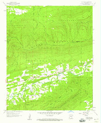
1958 Map of Cauthron
USGS Topo · Published 1959About this map
The Poteau River meanders through the central valley of this 1950s survey, marking a low-lying break between the high ridges of Poteau Mountain to the north and Walker Mountain to the south. The small community of Cauthron serves as a local focal point along the Kansas City Southern rail line, which follows the river's path east toward Oliver. This area within the Ouachita National Forest highlights a landscape defined by sharp elevation shifts, from the heights near Poteau Lookout Tower to the bottomlands where Sixmile Creek and Two mile Creek join the main river. Notable local landmarks for genealogists and historians include the Morgan Spring Ch and a Fish Hatchery near the eastern boundary, illustrating the area's rural religious and conservation infrastructure at the end of the decade.
Find a feature on this map
31 named features on this map. Tap any name to fly to it.
Don’t see what you’re looking for? This feature index may not catch every label — zoom into the map to look around manually.
Map Details
Editions of this 1958 Cauthron Map
Other maps of this area

1879 · Poteau Mountain
USGS Topo · 1:62,500

1887 · Poteau Mountain #1
USGS Topo · 1:62,500

1887 · Poteau Mountain #2
USGS Topo · 1:62,500

1887 · Greenwood
USGS Topo · 1:62,500

1890 · Fort Smith
USGS Topo · 1:125,000

1890 · Poteau Mountain
USGS Topo · 1:125,000

1899 · Poteau Mountain
USGS Topo · 1:125,000

1906 · Barber
USGS Topo · 1:62,500

1939 · Waldron
USGS Topo · 1:62,500

1940 · Waldron
USGS Topo · 1:62,500