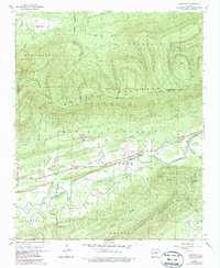
1958 Map of Cauthron
USGS Topo · Published 1979About this map
Cauthron and Oliver sit along the Kansas City Southern corridor in this late-1950s study of the western Arkansas borderlands. The landscape is defined by the heavy timber of the Ouachita National Forest and the winding course of the Poteau River. High points such as Sugar Loaf Mountain and Poteau Mountain dominate the northern half of the area, where the Poteau Lookout Tower stands as a sentinel over the forest. To the south, the terrain breaks into distinct ridges like Brawley Ridge and Walker Mountain. Evidence of early community life appears at Morgan Spring Church and the BM Patterson settlement near the Sebastian and Scott County line. The presence of a Gaging Station on the river and numerous water sources like Sixmile Creek and Gum Branch highlight the importance of water management in this rural upland environment.
Find a feature on this map
34 named features on this map. Tap any name to fly to it.
Don’t see what you’re looking for? This feature index may not catch every label — zoom into the map to look around manually.
Map Details
Editions of this 1958 Cauthron Map
Other maps of this area

1879 · Poteau Mountain
USGS Topo · 1:62,500

1887 · Poteau Mountain #1
USGS Topo · 1:62,500

1887 · Poteau Mountain #2
USGS Topo · 1:62,500

1887 · Greenwood
USGS Topo · 1:62,500

1890 · Fort Smith
USGS Topo · 1:125,000

1890 · Poteau Mountain
USGS Topo · 1:125,000

1899 · Poteau Mountain
USGS Topo · 1:125,000

1906 · Barber
USGS Topo · 1:62,500

1939 · Waldron
USGS Topo · 1:62,500

1940 · Waldron
USGS Topo · 1:62,500