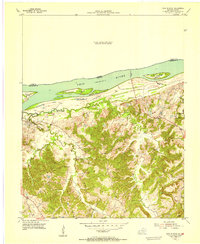
1954 Map of Cave In Rock
USGS Topo · Published 1955About this map
The Ohio River forms a dominant boundary along the northern edge of this Crittenden County landscape, serving as a vital transport corridor defined by prominent landmarks like Hurricane Island and Cave in Rock Island. Inland, the terrain rises sharply from the river bottoms into a series of ridges and hollows, where the small community of Tolu serves as a local hub. The map illustrates a rural economy transitioning from mid-century agricultural life toward industrial exploration, evidenced by the Memphis Prospect Area in the southeast corner. Social life for the area's residents appears centered around modest rural institutions, including the Hebron Sch and several family-named landmarks. The presence of the Cave in Rock Ferry underscores the continued importance of river crossings for connecting Kentucky and Illinois, while cemeteries such as Hurricane Cem and Dunn Spring Cem provide essential data points for family historians tracing local lineages.
Find a feature on this map
23 named features on this map. Tap any name to fly to it.
Don’t see what you’re looking for? This feature index may not catch every label — zoom into the map to look around manually.
Map Details
Editions of this 1954 Cave In Rock Map
This is the sole edition of this map. No revisions or reprints were ever made.
Other maps of this area

1916 · Shawneetown
USGS Topo · 1:62,500

1916 · Fords Ferry
USGS Topo · 1:62,500

1916 · Golconda
USGS Topo · 1:62,500

1916 · Equality
USGS Topo · 1:62,500

1920 · Goloonda
USGS Topo · 1:48,000

1921 · Fords Ferry
USGS Topo · 1:48,000

1921 · Golconda
USGS Topo · 1:62,500

1925 · Cave In Rock
USGS Topo · 1:62,500

1949 · Paducah
USGS Topo · 1:250,000

1950 · Paducah
USGS Topo · 1:250,000