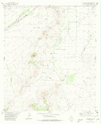
1980 Map of Cave Mesa NE
USGS Topo · Published 1980About this map
Pikes Peak rises as a prominent landmark in this West Texas landscape, surrounded by the industrial footprints of the late twentieth-century energy and transport sectors. The northwestern portion of the map is defined by the Atchison Topeka and Santa Fe railroad, which parallels a major Pipeline and the seasonal waters of Acebuche Draw. Extensive infrastructure for natural resource extraction is visible throughout the area, evidenced by numerous Gas Wells and Oil Wells. The infrastructure of the ranching and energy economy is further marked by the Oates Pumping Sta and a remote Landing Strip near Belding Draw. This map captures a specific moment when heavy industry, such as numerous Gravel Pits, operated alongside the traditional drainage patterns of the Pecos County desert.
Find a feature on this map
12 named features on this map. Tap any name to fly to it.
Don’t see what you’re looking for? This feature index may not catch every label — zoom into the map to look around manually.
Map Details
Editions of this 1980 Cave Mesa NE Map
This is the sole edition of this map. No revisions or reprints were ever made.
Other maps of this area

1921 · Fort Stockton
USGS Topo · 1:62,500

1923 · Fort Stockton
USGS Topo · 1:62,500

1923 · Sierra Madera
USGS Topo · 1:62,500

1928 · Comanche Spring
USGS Topo · 1:125,000

1929 · Hovey
USGS Topo · 1:125,000

1954 · Fort Stockton
USGS Topo · 1:250,000

1958 · Fort Stockton
USGS Topo · 1:250,000

1970 · Belding SW
USGS Topo · 1:24,000

1970 · Twelvemile Mesa
USGS Topo · 1:24,000
1970 · Belding
USGS Topo · 1:24,000