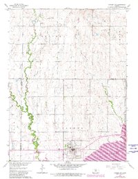
1962 Map of Cawker City
USGS Topo · Published 1980About this map
Cawker City stands as the central hub of this north-central Kansas landscape, situated just north of the Solomon River and the expanding waters of Waconda Lake. This survey captures the region during a period of transition, reflecting both the long-standing agricultural grid and the influence of the Missouri Pacific Railroad running through the river valley. The map is a vital resource for genealogists, documenting rural social centers such as Chandler Sch and several burial grounds, including Reformed Cem, Rooker Cem, and Prairie Grove Cem. The drainage patterns of Oak Creek, Little Oak Creek, and Granite Creek define the local topography, while scattered industrial sites like a Quarry and multiple Gravel Pit locations indicate the extraction of local materials. The inclusion of a Landing Strip and a modern Rest Area reflects the evolving transportation infrastructure of the mid-20th century.
Find a feature on this map
23 named features on this map. Tap any name to fly to it.
Don’t see what you’re looking for? This feature index may not catch every label — zoom into the map to look around manually.
Map Details
Editions of this 1962 Cawker City Map
3 editions found

Other maps of this area

1893 · Smith Center
USGS Topo · 1:125,000

1894 · Mankato
USGS Topo · 1:125,000

1894 · Beloit
USGS Topo · 1:125,000

1896 · Osborne
USGS Topo · 1:125,000

1953 · Downs South
USGS Topo · 1:24,000

1953 · Waconda Springs
USGS Topo · 1:24,000

1953 · Glen Elder South
USGS Topo · 1:24,000

1955 · Beloit
USGS Topo · 1:250,000

1959 · Beloit
USGS Topo · 1:250,000

1960 · Downs North
USGS Topo · 1:24,000