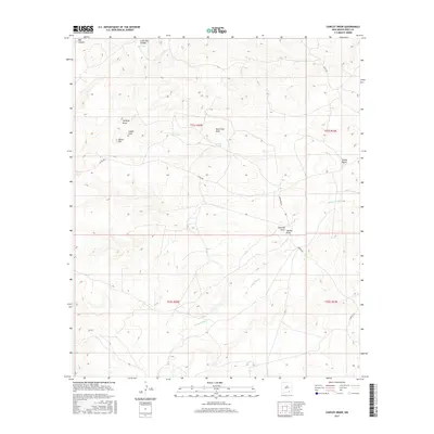
2017 Map of Cawley Draw
USGS Topo · Published 2017About this map
Burro Hill and the surrounding high desert of Eddy County are defined by an intricate network of seasonal drainages and water catchments vital to this arid landscape. The area is marked by significant topographical relief, including the steep-walled Box Canyon and Little Box Canyon to the north. Water management is a primary feature of the human imprint here, evidenced by named reservoirs such as Big Tank, CCC Tank, Loafer Tank, and Burro Tank. These features suggest a history of ranching and resource management in a region where surface water is scarce. The drainage pattern is dominated by Rocky Arroyo, which serves as the primary conduit for runoff from numerous smaller features like Stinking Draw, Bone Tank Draw, and Cawley Draw. Remote access is provided by unpaved routes like Marathon Rd and Cowley Rd, which navigate the terrain around the Indian Basin.
Find a feature on this map
22 named features on this map. Tap any name to fly to it.
Don’t see what you’re looking for? This feature index may not catch every label — zoom into the map to look around manually.
Map Details
Editions of this 2017 Cawley Draw Map
This is the sole edition of this map. No revisions or reprints were ever made.
Other maps of this area

1940 · Bandanna Point
USGS Topo · 1:62,500

1943 · Bandanna Point
USGS Topo · 1:62,500

1943 · Texas Hill
USGS Topo · 1:62,500

1945 · Texas Hill
USGS Topo · 1:62,500

1954 · Carlsbad
USGS Topo · 1:250,000

1957 · Foster Ranch
USGS Topo · 1:24,000

1957 · Box Canyon Ranch
USGS Topo · 1:24,000

1958 · Carlsbad
USGS Topo · 1:250,000
1978 · Bandanna Point
USGS Topo · 1:24,000

1978 · Strychnine Draw
USGS Topo · 1:24,000