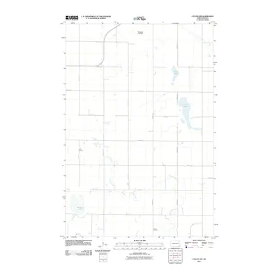
2011 Map of Cayuga NW
USGS Topo · Published 2011About this map
Crooked Creek meanders across this rural section of Sargent County, defining the drainage patterns of a landscape marked by scattered prairie lakes and depressions. To the north, the Fangsrud Lake Bed suggests a shifting hydrological history, while established water bodies like Lake Fedge, Borg Lake, and Kandiotta Lake punctuate the grid of gravel section roads. This 2011 survey documents a sparsely populated agricultural region where the continuity of local heritage is anchored by quiet landmarks. Genealogists and local historians can locate Union Cemetery in the western reaches and Shuman Cemetery to the south, both serving as important points of reference for families tied to Herman Township and the surrounding countryside.
Find a feature on this map
22 named features on this map. Tap any name to fly to it.
Don’t see what you’re looking for? This feature index may not catch every label — zoom into the map to look around manually.
Map Details
Editions of this 2011 Cayuga NW Map
This is the sole edition of this map. No revisions or reprints were ever made.
Other maps of this area

1907 · Wyndmere
USGS Topo · 1:125,000

1953 · Fargo
USGS Topo · 1:250,000

1956 · Fargo
USGS Topo · 1:250,000

1958 · Rutland
USGS Topo · 1:24,000

1958 · Cayuga NW
USGS Topo · 1:24,000

1958 · Hamlin
USGS Topo · 1:24,000

1958 · Geneseo
USGS Topo · 1:24,000
1958 · Cayuga
USGS Topo · 1:24,000

1960 · Lisbon SE
USGS Topo · 1:24,000

1960 · De Lamere
USGS Topo · 1:24,000