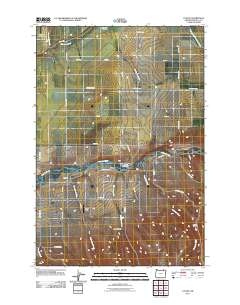
2011 Map of Cayuse
USGS Topo · Published 2011About this map
The Umatilla River serves as the central artery of this landscape, carving through the terrain where the settlement of Cayuse and its Cayuse Post Office are situated. This 2011 survey documents a rural environment in Umatilla County characterized by a network of drainage systems, including Moonshine Creek, Cottonwood Creek, and Wildhorse Creek, which flow toward the river valley. The topography is defined by significant features such as Kanine Ridge and Doe Canyon, while smaller local settlements like Minthorn and Homly are connected by a grid of named rural roads. This era of the landscape is marked by open spaces such as Quail Field and specialized infrastructure like the Rothrock Landing Strip, illustrating the modern balance of agricultural land use and light aviation in the region.
Find a feature on this map
44 named features on this map. Tap any name to fly to it.
Don’t see what you’re looking for? This feature index may not catch every label — zoom into the map to look around manually.
Map Details
Editions of this 2011 Cayuse Map
This is the sole edition of this map. No revisions or reprints were ever made.
Other maps of this area

1935 · Pendleton
USGS Topo · 1:125,000

1953 · Pendleton
USGS Topo · 1:250,000

1956 · Pendleton
USGS Topo · 1:250,000

1964 · Thorn Hollow
USGS Topo · 1:24,000

1964 · Athena
USGS Topo · 1:24,000

1964 · Meacham
USGS Topo · 1:24,000

1966 · Cabbage Hill
USGS Topo · 1:24,000
1966 · Adams
USGS Topo · 1:24,000
1966 · Cayuse
USGS Topo · 1:24,000

1966 · Table Rock
USGS Topo · 1:24,000